Follow Me on Pinterest
Showing posts with label Alpujarra Almeriense. Show all posts

Wednesday, May 25, 2016

Walking is thirsty work!

The fuentes of Berja
by Robert Bovington

Quite often my wife and I travel from Roquetas to the beautiful Alpujarras and often we stop in or near the attractive town of Berja for a coffee break.

However, occasionally we visit Berja because we like the town and like strolling along its quaint historic streets.

One of the noticeable features of Berja is its fuentes (fountains) -  there are more than thirty of them scattered around the town and its nearby environs! When you think that the province of Almería is the sunniest, driest part of Spain, you might wonder where the water is coming from! In the past, the Sierra de Gádor was heavily mined, mainly for lead and silver but now water is its biggest treasure. The mines were abandoned in the early nineteenth century but water, surprisingly, still appears to exist in sufficient quantities.

In villages like Berja there are numerous fuentes where water can be obtained – the meagre rainfall and the melted snow from the high sierra is efficiently stored and purified before being released as pure clean water.

So, a walk that takes in some of these fuentes is not a bad idea. 

The place to start is the tourist office - the young lady there is most helpful and will provide leaflets in Spanish and English. One of the leaflets features the famous fountain routes - you don't have to do them all in one day especially as some of them are rather off the beaten track.

Go in Spring or Autumn - it's best to avoid going in the heat of summer - even winter can be pleasantly warm at times! Take a container to fill with water - it's free and probably tastier than bought water!

Not far from the tourist office is the main plaza where the Town Hall and church (Iglesia de la Anunciación) are situated as well as one of the fountains  - the fuente de los 16 caños.

fuente de los 16 caños

Enjoy your walkl(s)!


www.tablondeanuncios.com

more blogs by Robert Bovington...
"Photographs of Spain"
"postcards from Spain"
"you couldn't make it up!"
"a grumpy old man in Spain"
"bits and bobs"
"Spanish Expressions"
"Spanish Art"
"Books About Spain"

Wednesday, December 31, 2014

Padules (Alpujarra Almeriense)


The stone paved streets of Padules are typical of the Alpujarras — the façades of the houses whitewashed and little pots of plants sit on windowsills behind wrought-iron railings.

 Robert Bovington
www.tablondeanuncios.com


more blogs by Robert Bovington...
"Photographs of Spain"
"postcards from Spain"
"you couldn't make it up!"
"a grumpy old man in Spain"
"bits and bobs"
"Spanish Expressions"
"Spanish Art"
"Books About Spain"

Wednesday, November 16, 2011

Dalías (Alpujarra Almeriense)

Dalías is a town in the province of Almería. It consists of two main areas - Dali and Celín. Sitting as it does in the foothills of the Sierra de Gádor, Dalías is often considered part of the Alpujarra Almeriense. Certainly its northern boundaries are extremely picturesque – the mountains loom over the town and the Celín area is extremely rural and the Celín Recreation Area is a pleasant place for a picnic.

picnic site at Celín

South of the town is a different matter. The Campo de Dalías is, in my view, the ugliest area in the whole of the province of Almería with its ocean of plastic, the ubiquitous invernaderos. 30,000 hectares of agricultural greenhouses have, since the 80's, sprung up in the south western region of Almería. Maybe they are an improvement on the original Campo de Dalías because author Gerald Brenan wasn’t too enamoured with the area either. In his book ‘South from Granada’ he wrote “…a depressing sight met my eye. For fifteen miles the road ran in a perfectly straight line across a stony desert……it is a delta of stone and rubble pushed eight miles into the sea by the erosion of the Sierra de Gádor…”.


But back to Dalías – it has a number of attractive buildings – none more so than its main church, Iglesia Parroquial de Santa María de Ambrox. It is large – surprisingly so considering the size of the town and is extremely appealing both within and without. It has had a troubled history. It has been destroyed and severely damaged on a number of occasions since it was first erected in the 16th century. It was first occasion was during the Morisco rebellion in the Alpujarras in 1568. An earthquake caused its complete destruction in 1804 and as recently as 1993 a fire caused extensive damage. Today, it is a delightful building and is situated in an attractive plaza close to the town hall. 

Iglesia Parroquial de Santa María de Ambrox

Casino
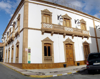
A short walk away, is the Casino de Dalías which was built in the early twentieth century but which resembles a nineteenth-century style town house. It has an ornate façade and is the hub of the social and cultural life of the town with dances and concerts.

One of the great assets of towns located in the Sierra de Gádor is water. There are many fuentes in the Dalías area and the town council have installed signs to accompany a tourist trail that incorporates twenty of these watering places. The trail is called ‘La Ruta de las Fuentes de Dalías’. It starts at the Fuente de Peregrino and finishes at the Arroyo de Celín, a delightful recreation area for walking and for picnics (if you don’t mind ducks trying to share your food).

Fuente del Doctor Vicente Granados
Saint José María Rubio y Peralta
(picture in Iglesia Parroquial de
Santa María de Ambrox)

Of the famous people of Dalías, I will mention two:
José María Rubio (1864-1929) was the first and only saint born in the province of Almería.
Juan Callejón Villegas, a 19th century diplomat, the great great grandfather of actress Helena Bonham Carter.

Robert Bovington
Roquetas de Mar Nov 2011


Ayuntamiento de Dalías

Sunday, November 13, 2011

Sierra de Gádor

by Robert Bovington

The Sierra de Gádor mountain range is situated in the south-western corner of the province of Almería. It belongs to the Betic system, specifically the Cordillera Penibética . The maximum altitude is 2249 meters – the summit of Launilla Morrón.
To the north is the Sierra Nevada; to the south lies the Mediterranean Sea whilst the Sierras Alhamilla and Contraviesa lie respectively to the east and west.


Sierra de Gádor nr Enix

At the foot of the Sierra de Gádor lies the region of the Poniente Almeriense (Western Almería), traditionally called the Campo de Dalias which, in my opinion, is by far the least attractive part of the diverse region of Almería. Author Gerald Brenan didn’t like it either – “…a depressing sight met my eye. For fifteen miles the road ran in a perfectly straight line across a stony desert…” was part of his description of the Campo de Dalías in his book “South to Granada”. Nowadays the stony desert is replaced by an ocean of plastic, the ubiquitous invernaderos. These greenhouses may have allowed the province of Almería to become Europe's market garden but they sure look ugly!
Never mind, the Sierra de Gádor is a pleasant, largely unspoilt mountain range that is technically part of that delightful region of the Alpujarras. The following towns are within its boundaries:
Felix , Enix , Gádor , Alhama de Almería , Alicún , Huécija , Íllar , Instinción , Rágol , Fondón, Laujar de Andarax , Alcolea, Berja , Dalías and Vícar .

statue of a miner in Fondón

In the past, the Sierra de Gádor was heavily mined, mainly for lead and silver but now water is its biggest treasure. The mines were abandoned in the early nineteenth century. Water, surprisingly, still appears to exist in sufficient quantities. In villages like Berja, Felix and Dalías there are numerous fuentes where water can be obtained – the meagre rainfall and the melted snow from the high sierra is efficiently stored and purified before being released as pure clean water.

a fuente in Dalías

Robert Bovington
Nov 2011

Wednesday, October 26, 2011

A drive in the Alpujarras

.
Bayárcal is the highest village in the Almeriense Alpujarras at over 4000 feet.

The village is surrounded by an oak forest and nearby are groves of chestnut, pine and cherry. In October, the local villagers can be seen collecting chestnuts.


The scenery around this area is spectacular and I quite often drive little circular routes around this area. One suggestion is to start at Cherín and follow the A337 through Picena to Laroles. At a junction take the road to Bayárcal then Paterna del Río and on to Laujar de Andarax. Thence travel along the A348 back to Cherín.


Cherín

An excellent deviation, if you have time, is to visit Puerto de Ragua, which, at 2000 metres above sea level, is the only road that links the south and north faces of the Sierra Nevada. Puerto de Ragua is a pleasant place to walk or have a picnic. Snow covers this area from November until April. To drive there continue north from Laroles instead of taking the road to Bayárcal.


Puerto de Ragua
more blogs by Robert Bovington... 

Sunday, October 16, 2011

Alboloduy - a village in the Alpujarra Almeriense


Alboloduy is nestled at the foot of a mountain with orchards of citrus, grape and olive spread out across the valley below. A lovely looking church stands prominent amidst the little white houses of Arabic origin that tumble down the hillside. The town is situated in the Sierra Nevada Natural Park. 


Saturday, June 11, 2011

Photo of Padules, Alpujarra Almeriense


The stone paved streets of Padules are typical of the Alpujarras — the façades of the houses whitewashed and little pots of plants sit on windowsills behind wrought-iron railings.